 December, 2018
Or, perhaps I should ask “where’s my driver’s license?” I’ve actually lost my license twice when traveling.
The first time was on Bourbon Street in New Orleans. I was sober at the time, but when purchasing something to remedy that situation, my license fell out of my wallet. Panic!! I called my neighbor and let her into my house (Control4 Home Automation with a smartphone app), and told her where my passport was. She took it to my office where they overnighted it to me. Fortunately, a very nice person found my license and mailed it back to me.
The second time was in Los Angeles. I discovered the loss when standing in line for security at LAX. Panic!! No time to have the neighbor come to my rescue. I learned that it is possible to board the airplane, but you will go through a more thorough search and will be required to answer some questions. If the TSA agent can confirm your identity, you will be allowed to fly.
Now, my passport goes with me whenever I fly, so I have a backup plan if I lose that license again. Amtrak also requires an ID, so it’s just best to bring it wherever you travel.
As we prepare for our next overseas trip, I’m busy figuring out what we need to pack, where we need to be and when, how to survive many hours in flight, all with minimal stress. Good luck with that, right?
Over the years, we’ve learned a few things to make it easier, which I’m sharing with you (if you are interested, that is.)
PASSPORTS:
You may already know that many countries require your passport to be valid for at least six months past your travel date. Did you also know that some countries require a minimum number of blank pages for entry. For instance, when we traveled to South Africa, we needed two pages for each entry and exit. Since we entered and exited twice, that meant four blank pages. You can no longer order extra pages for your passport, so if you’re running short, you will need to renew it.
Consider making a photocopy of your passport and storing it in your wallet or another place separate from your real one. In some countries, the UK for one, hotels are required to record your information, which they can get from a photocopy, so you might want to bring a few copies along. The hotel may ask to keep your passport, but they should be able to get by with the photocopy. Also, give a copy to a trusted friend or family member in case of emergency. Finally, we keep a copy in Google Drive so we can access it from anywhere with cellphone or WIFI access.
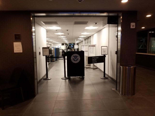
GLOBAL ENTRY VS TSA Pre✓®
TSA Pre✓® costs $85 for 5 years, but is only good for travel within the US, wherever TSA Pre✓® is available. Global Entry costs only $15 more, is also good for 5 years, and it is good for travel within the US and for re-entering the US. It also works in several few international airports, check on-line to see if you can take advantage of that benefit. Global Entry gives you the same TSA Pre✓® benefits, so the price difference is very little to pay if you will be traveling internationally. When entering through a major airport, like MSP, you go to a kiosk at passport control where you scan your passport and your fingerprints. Once your identity is confirmed, you continue on to customs, without stopping at the passport desk.
You can apply on-line for Global Entry or TSA Pre✓® at the U.S. Department of Homeland Security You will be contacted within 24 hours to set up an interview appointment at an enrollment center. Ours was at MSP airport. They take your fingerprints, and ask a few questions. If approved, you will receive your Global Entry card in 4-6 weeks.
There are also programs for frequent travel to Canada (Nexus) or to Mexico (Sentri). Both of them include TSA Pre✓®, when flying, and each gives you expedited pedestrian or vehicle entry across the applicable border. We have not tried either of these.
 It really is gratifying to walk past the lines of people waiting to see a border agent.
BTW: If you have to replace your passport before the Global Entry expiration date, you will need to update your profile on-line.
MSP is one of about 40 airports that also offer CLEAR, a biometric service using your irises and fingerprints. It allows you to go to a much shorter screening line to get to security. It doesn’t replace TSA Pre✓® or Global Entry, but it does get you to the head of the line much more quickly when traveling in the US. You will still need at least TSA Pre✓® to avoid taking off your shoes and removing your laptop. Clear costs $179 per year, probably worth it for frequent travelers, and certain credit cards will give you credit towards the fee. Up to 3 family members can be added for $50 each. We haven’t opted for it yet, but if screening lines get too long, even with TSA Pre✓®, we may give it a try. UPDATE: We did purchase CLEAR in late 2019. We love it!
COMMUNICATION:
Ask your cellphone provider if there is coverage in the countries where you will be traveling. If not, consider purchasing a SIM card when you get to your destination. If you have WIFI access, there are quite a few apps that let you call, text, even video chat without additional fees. We’ve used both Google Hangouts and WhatsApp.
We have not used any translation apps, but there are quite a few out there, and they might be worth looking into.
GETTING AROUND:
Uber is everywhere. If you haven’t already tried it, download the app and take a ride before you go so you can see just how it works. We’ve used it in several cities with very few mishaps. You prepay for the ride (tip included, but you always add more). There are a few options regarding vehicle size, shared rides, etc, that you can select if you wish. You will be notified of your driver’s name, the type of vehicle he/she is driving, and car license, so you know what car to get into. You can also track your vehicle’s approach on your phone, which is especially helpful in busy traffic.
I did have one issue that I reported to Uber (the driver drove through a stop sign), and the fare was refunded. I wasn’t expecting a refund, simply wanted them to know about a safety concern. Great service!
We haven’t tried Lyft yet. That service is widely available in the US, but not internationally except for Ontario, Canada.
If you want to use local public transit, check out the Transit app. It works in most large US cities, and it’s available in several cities in Canada and Mexico as well as overseas. This app will give you information about all of the local transit options (bus, subway, metro, light-rail, etc.), along with their schedules. Simply enter your destination to find the best methods to get there from your current location. You can also find bike sharing locations.
If you ever visit downtown Minneapolis, there is an app for the skyway system, called SkyWayNav. This link is for the android version. I wasn’t able to find an iPhone version. It’s not perfect, but you won’t mind too much when the outdoor temperature is 20 below!
CURRENCY:
It’s nice to have some local currency for incidentals. Your bank might be able to purchase some for you ahead of time, or you can look for an ATM when you arrive at the airport. I usually try to bring some Euros home with us since we will probably travel to Europe in the future.
On one trip to Italy, I forgot to stop at the ATM in the airport. I had about 45 Euros in coin, which was enough to pay our driver, but not enough for a tip. I’m sure our driver didn’t appreciate getting a handful of coins, nor getting stiffed for a tip. It was embarrassing! Our hotel used that driver fairly often, so I was able to leave a tip for him the next day.
CREDIT CARDS:
Use a card that doesn’t charge foreign transaction fees. There are several out there. Frequently, you can get better exchange rates through the card than you can at a local exchange bureau. Be sure, though, to contact the credit card company to let them know which countries you will be traveling in so your card doesn’t get shut down for fraud concerns. Yes, this has happened to us, though not overseas. We use American Express for most purchases, but also bring a VISA or MasterCard for those few places that don’t accept AMEX.
That’s enough for today. Happy travels!
 Personally, I find the title of this book to be a bit misleading. That didn’t prevent me from thoroughly enjoying it. I read