Glacier Bay

Saturday, August 13, 2016

We woke to rain and fog again as we entered Glacier Bay National Park. In spite of the rain, we decided to walk around the deck in order to see as much as possible. It didn’t take long to get very wet and cold even though we were wearing our rain gear.

This park is comprised of 3.3 million acres of stunning beauty – glaciers, forests, fjords, mountains, bears, wolves, foxes, whales, seals, puffins, eagles and much, much more. When explored by Captain George Vancouver in 1794, Glacier Bay was more than 4,000 feet thick and up to 20 miles wide and more. It extended more than 100 miles. Less than 100 years later, John Muir found that the ice had retreated almost 50 miles up the bay.

There are several types of glacier: tidewater, alpine, ice caps, valley and others. We saw several tidewater glaciers – those that reach the sea. Tidewater glaciers exist in only three places on earth: Chile, Scandinavia and Alaska.

We saw many icebergs. Here too, there are several types. We saw shite bergs, which hold trapped air bubbles; blue bergs which are very dense and hold little air (they absorb white light while reflecting blue); and greenish-black bergs which have calved off from glacier bottoms (they carry moraine, the rocky rubble picked up along their journey to the sea.)

Margerie Glacier – We were fortunate to both see and hear some calving, where portions of the glacier break off into the sea.

IMG_7261

Grand Pacific Glacier – full of moraine.

IMG_7339

Johns Hopkins Glacier

Posted in Alaska, National Parks, USA Travel | Tagged | 2 Comments

Home of the North Wind

Friday, August 12, 2016

I have to refer to the ship newsletter for the day and date – so nice.

Skagway is an old Gold Rush town founded in 1897 when Captain William Moore staked a claim and built a wharf in anticipation of the rush for Klondike gold. The town’s name is based on the Tlingit word Schkagua, which translates to Home of the North Wind. Situated in a U-shaped glacial valley, it is slowly rebounding by 1 – 2 inches per year.

The route to the Klondike gold fields was by way of the Chilkoot Trail and the White Pass, snow-covered, rugged and time-consuming routes. In 1898, construction began on the White Pass & Yukon Railway, with the final spike hammered home two years later.

Skagway has restored much of its downtown, and is a lively tourist town, with historic reenactments and history tours led by costumed guides.

The White Pass and Yukon Route operates both diesel-electric and steam engines. In the winter, snow blower/ice cutter engines were employed to cut through the snow and ice on the rail.

This afternoon, we boarded a car that runs as far as the Canadian border, just over 20 miles from downtown Skagway, about a 3 hour round trip. The total route is about 110 miles, ending in Whitehorse, Yukon Territory, Canada. We rode along the Yukon River between towering mountains. The scenery was absolutely stunning.

Back on the ship for some more beautiful scenery, including a gorgeous sunset as we cruised towards Glacier Bay.

IMG_7199


Posted in Alaska, Crystal Cruises, National Parks, USA Travel | Tagged , | Leave a comment

Blue Alaska

Thursday, August 11, 2016

When we arrived in Juneau this morning, it was foggy and rainy. Big surprise! I should not be surprised that it is so humid along the inside passage of Alaska. After all, it is temperate rainforest.

Although Juneau is the state capital, that was not always the case. The original capital was in Sitka, and was moved to Juneau in 1913. When Alaska became a state in 1959, Alaskans voted to move the capital closer to the major population areas of Anchorage and Fairbanks, but that proved to be too costly.

Juneau’s main industry is government, which employs one-third of the residents. Fishing is also important as is tourism – quite evident as you walk down the streets of the city.

Today’s highlight was a helicopter trip to Mendenhall Glacier, where we were able to spend some time on the glacier itself. We took a 15 minute ride over the city of Juneau with Temsco Helicopters, Inc. We flew over the glacier for several minutes, which allowed us to see the extent of it. There is more than one branch, and from the air it really does look like a river of ice. There are several waterfalls falling onto the glacier and off of it.

It was very windy on top of the glacier, the Alaskan flag at the base site was flying almost parallel to the ground. Our guide, Georgia, did an excellent job of explaining the composition and history of the glacier. Mendenhall is about 13 miles long, and where we were standing about 1.5 miles across. The glacier is “unhealthy,” meaning it is losing ice more quickly than adding it. It’s very wet at the top, and we had to be careful walking so we wouldn’t slip and fall. There are several streams running across. We could taste the glacial water if we wished, either safely by scooping it into our hands, or by doing a glacial pushup and slurping the water up. Mark was much more successful at that than I was. The water is cold, especially when you fall into it!

The blue color comes from the density of the compacted snow and from a lack of oxygen below the surface. Our helicopter pilot told us that the glacier actually looks more blue on a cloudy day like today than on a sunny one, so good timing for us.

Glaciers expand and contract, with crevasses opening and closing over time. Any rocks that get caught in the crevasse will be crushed to a silty granular substance. One of the shops in Juneau actually sells glacier silt soap as an exfoliant. Our guide demonstrated a far less expensive alternative to us, and told us it would immediately take five years off our looks – I should have scooped some up to bring home.

We returned to Juneau in the afternoon, exhilarated by our adventure.

Posted in Alaska, Crystal Cruises, USA Travel | Tagged , | 2 Comments

Where the North Wind Doesn’t Blow

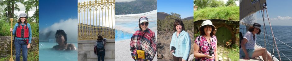
Wednesday, August 10, 2016

Hoonah, Chicagof Island

Again,  it was foggy and rainy, but that’s good weather for bear watching, since that is when salmon like to run. Hoonah has been inhabited by the Tlingit peoples for several hundred years. When they settled here, they originally called this Gaawt-ak.aan, which means village by the cliff. In time, that was changed to Xu.naa, or where the north wind doesn’t blow.

The Huna Totem Corporation, Tlingit Nation, has invested a great deal in making this island attractive to tourists. Our ship docked at a floating dock, and we walked under a covered walkway a few hundred feet from the ship to land.

From there, we made our way to The Cannery, a former salmon canning facility that has been converted to a museum about the industry. The town also installed what is being billed as the World’s Largest ZipRider, which takes its riders on a mile long journey from 1,300 feet above sea level.

In the afternoon, we went looking for brown bear with Hoonah Travel Adventures. A brown bear is actually a grizzly bear. Generally, Grizzly is used to refer to any brown bear found in interior North American, while Kodiak refers to brown bears on Kodiak Island, and Coastal Brown Bear refers to all of the brown bears on the other islands. Some scientists believe that all brown bears are descended from polar bears. When the glaciers receded, the bears left in the southern part of the polar bear range became the brown bears. Brown bears vary in color from golden brown to dark brown and even silver.

Hoonah has a large concentration of brown bears, with about 3,500 on this small island. The largest male yet discovered stood about 12 feet on its hind legs and was estimated to weigh about 1,500 pounds.

We had a couple of guides, Chad who walked with us and informed us about the history and habitat of the bears, and George, a full blood Tlingit who scouted ahead and provided protection if anything untoward would occur. Fortunately, George  didn’t need to use his weapon.

IMG_6701

Guides Chad and George

Before we even arrived at the viewing trail, we were treated to views of a bear fishing in the river, as well as several black tailed deer. Once we arrived at the viewing trail, we saw the same bear again, and were able to watch as he did a bit more fishing. The salmon are spawning right now, and we could see a lot of activity in the river. I was even treated with a view of a couple of salmon jumping – no chance to get any photos though.


As we were driving away, we saw a brown bear on the road ahead. Then, we saw a second. Then, a third. And a fourth! So very exciting. These were brothers, about ten years old. Male siblings will stay together until they reach full maturity and then head out on their own. The average life span is 35 years.

IMG_6792

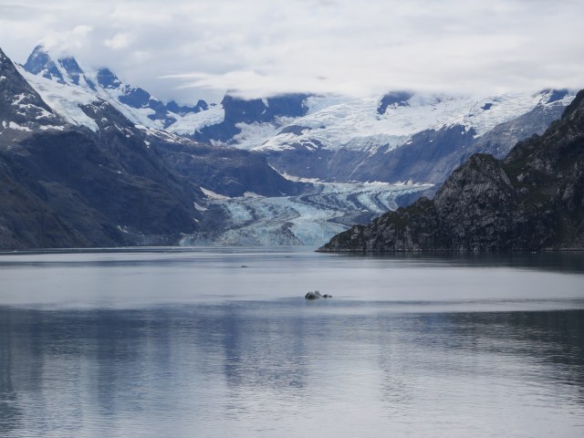
This was in the Tongass National Forest, which actually spans several islands. We were in the Tongass Forest yesterday at Ketchikan. The Tongass is the largest temperate rainforest in the world, and the second largest rainforest over all – the largest being in the Amazon.

Wonderful day.


Posted in Alaska, Crystal Cruises, USA Travel | Tagged , , | Leave a comment

Thundering Wings of an Eagle

Tuesday, August 9, 2016

We pulled into port about 8:00 am. Cloudy and drizzly, which is normal. Ketchikan is known as the Rain Capital of Alaska and experiences an average of 162 inches of rain annually, with measurable precipitation 240 days of the year.

The native Tlingits called the place “Kitschk-him” which translates to “thundering wings of an eagle.” Tlingits fished for salmon here during the summers. When the white people came here, they also began to harvest salmon, and also mined for gold and other minerals in the surrounding hillsides.

Mining died out in the 1920’s, and the salmon declined in the 40’s, but the lumber industry became a vital part of the city’s economy. Salmon is big here, with Ketchikan also known as the Salmon Capital of the World.

We headed out this morning with Alaska Travel Adventures to Harriet Hunt Lake. Our bus driver, Nina from Orlando FL, regaled us with stories and legends of Alaskans and Native Americans, which made the 40 minute trip fly by. She told us about the Fireweed flower, growing along the road. It blooms from the bottom to the top. Legend has it that once the top flowers bloom, snow is only six weeks away. This flower gets its name from the fact that it is the first plant to return after a fire.

IMG_6586

Fireweed

Upon reaching the lake, we boarded one of two canoes, each carrying about fifteen passengers – ours with guide, John from Asheville NC. Mark and I were fortunate enough to be at the front of the canoe, except that we couldn’t see if the other passengers were pulling their weight (I’m thinking we were doing all of the paddling.) This pristine lake is nestled between hills, and reaches a depth of about 300 feet. While we weren’t fortunate enough to see any wildlife, we were not disappointed overall.


We stopped for a short hike through the surrounding rainforest. Our guide, John, did an excellent job of explaining the sights. Among the trees in this area are towering cedar, Sitka spruce (the Alaska state tree,) and western hemlock, among others.

Fallen trees often become nursery logs for other plants in the rainforest. Moss is the first to grown on the decaying tree, then other plants and trees begin to take root. After the fallen tree has fully decayed, the remaining trees will have root systems above ground. These systems are called stilted trees.

Back in Ketchikan, we strolled along a few of the streets. Many of the homes are built into the granite cliffs, and the downtown areas are accessible only by steep staircases or funiculars. There is even a trundle road, a road bed built to extend the driving surface over the land available.

There is a sculpture by Dave Rubins in downtown Ketchikan, The Rock, which honors Ketchikan’s past, including Native Americans, logging, mining, trapping and aviation.

IMG_6596

The Rock

By the end of the day, the fog had lifted and we were able to see the surrounding city and hills – truly lovely.

Posted in Alaska, Crystal Cruises, Uncategorized, USA Travel | Tagged , | Leave a comment

Alaska’s Inside Passage

Monday, August 8, 2016

Sailing the inside passage all day. The early morning fog lifted to reveal several islands, but mostly water, water, water. While I was taking some computer classes in the afternoon, many people experienced the thrill of seeing orcas and dolphins frolicking nearby.

Our ship is very comfortable – Crystal Serenity. We cruised with Crystal Cruises a few years ago and were so impressed that we jumped at the chance to travel with them again. A number of passengers will be staying onboard after we debark in Anchorage, to take the cruise through the Northwest Passage, ending in New York. It was tempting, but we weren’t ready for a month long cruise.

Mark and I are easy sailors, rarely experiencing even slight queasiness regardless of the waves. Like a cradle, the waves rock us to sleep. While on the treadmill this morning, I experienced changes in the incline without any mechanical adjustments – a little weird at first, but then it becomes natural.

When we disembark, we’ll have to take a few minutes to adjust to solid ground again.

Tonight was formal night, the only one on this cruise. While I enjoy dressing up, I hate trying to tie Mark’s bow tie. Sometimes I think we should just get a pre-tied one.

We have a lively group of table mates at dinner, with representation from Toronto, Ontario; Fresno, California; Sarasota, Florida, and central Minnesota – a nice geographic mix. Two of the folks are travel specialists, so we have the fun of sharing travel experiences and getting ideas for more places to explore.

Posted in Alaska, Crystal Cruises, Uncategorized, USA Travel | Tagged | Leave a comment

Leaving Vancouver

Sunday, August 7, 2016

This was our last day in Vancouver. We visited Science World for a few hours. It’s really designed for children, but we still enjoyed several of the exhibits. Outside of the museum was a piano with a sign for Pianos on the Street, a project started in 2009 designed to share the passion of music and inspire people to play. There are more than a dozen in Vancouver, and more are planned.

I was also pleased to see a poster advertising a DIY program for girls aged 12 – 15, Project DIY. Sounds like a great way to get girls involved in science.

I enjoyed the names of many of the bars and restaurants in this town. They reflect the creativity of the city’s inhabitants. I wish we could have tried them all. Perhaps we should stay another week? Maybe two would be good.

As we are leaving Vancouver, I want to leave you with some impressions of the city.

What a surprise it was to see Reddy Kilowatt on the side of a building in Vancouver. Reddy has been around since 1926, and was once owned by Northern States Power in Minnesota, but was retired in 2000. Reddy also represented the British Columbia Electric Company, and currently resides on the side of their old building near the gates of Chinatown.

Our ship left port around 10:30 pm on a beautiful night.


Posted in British Columbia, Canada, Crystal Cruises, Vancouver | Tagged , | Leave a comment

Granville Island

Saturday, August 6, 2016

We boarded our cruise ship this morning – Crystal Serenity – and then took a cab to Granville Island to visit the public market there.

IMG_6459

Crystal Serenity

Besides the Granville Island Public Market, there are several shops (yay!) and the Emily Carr University of Art and Design. It was a beautiful day to visit, with mostly clear skies and warm temperatures. We had been told that Vancouver is cloudy and cool more often than not so we have been very fortunate.

We will be docked in Vancouver for another day, so will be able to enjoy this lovely city again tomorrow.


Posted in British Columbia, Canada, Vancouver | Tagged | Leave a comment

Easy Day in Vancouver

Friday, August 5, 2016

We mostly walked around town today, through the Gastown District and along the Harbour, enjoying some of the interesting architecture in the area.

The harbour area was very busy. There is an anime convention occurring here this weekend – Anime Revolution – so lots of young people in costume. Anime refers to Japanese animationIMG_6408, dating back to 1917. The current style emerged in the 1960’s. It is distributed directly to home media and over the internet, and is classified into many genres.

We spent some time near the convention center before returning to our hotel before dinner.

Dinner tonight was at Glowbal Restaurant, a few blocks from our hotel. Mark enjoyed lamb shank while I had salmon. Again, an excellent day in Vancouver followed by an excellent meal.


Posted in British Columbia, Canada, Vancouver | Tagged , | 1 Comment

Sea to Sky

Thursday, August 4, 2016

The Sea to Sky Highway, Highway 99, runs from Vancouver along Howe Sound, a very scenic area. This part of British Columbia was covered by 2 kilometers (about 6,500 feet) of ice during the last ice age. The receding ice left the Howe Fjord, surrounded by mountain, and filled with steep islands which are accessible only by ferry or water taxi. We rode along this route for about an hour to Squamish.

The town of Squamish is named for the Squamish First Nation. Some years ago, there was concern that the Squamish language was disappearing, so the schools here began teaching the Squamish language to their students. As part of the effort to preserve the language, the road signs along the Sea to Sky Highway have place names written both in English and in Squamish.

Along the way, we rode by the town of Britannia Beach, home of a no longer operating copper mine. The mine had operated from 1904 to 1974, originally by the Britannia Mining & Smelting Company, and then by Anaconda Copper Company.

Our destination today was the Sea to Sky Gondola, located near the town of Squamish. The gondola took us up to about 550 feet above sea level, where we could access numerous trails. The area is popular with hikers, mountain bikers, rock climbers, mountaineers and tourists like us.

Once at the top, we walked across the Sky Pilot Suspension Bridge, a 500 foot bridge high above the land below to access the trails on the other side. The views were phenomenal, no matter where we went, and we could see several glaciers on the peaks that surrounded us.

After a few hours, we returned to Vancouver, and decided to have pizza at Boston Pizza just across the road from our hotel. While there, we noticed that the delivery person was riding an electric scooter to make deliveries. Mark asked about it and the young man joined us for a nice conversation about Vancouver and its growing film industry. He is an actor, hoping for his break, delivering pizzas in the meantime. We really enjoyed visiting with him, and he gave us some good suggestions for further touring.

The scooter is made by Motorino, a Vancouver based company founded by Steven Miloshev in the early 2000’s, to build electric bikes and scooters. These machines can be operated without a driver’s license, adding to their appeal. Also, the scooters cost less than $3,000.

We have noticed several docking stations in the city for bicycles. These are part of a Mobi public bike share program through the City of Vancouver. People who wish to use the bikes sign up for a Mobi membership and pay for time used. The city plans to have 1,500 shared bicycles and 150 stations available by the end of this summer.


Posted in British Columbia, Canada, Uncategorized, Vancouver | Tagged , , | Leave a comment